Sunday, December 6, 2015

7.4 - Research Assignment: Sense and Avoid Sensor Selection


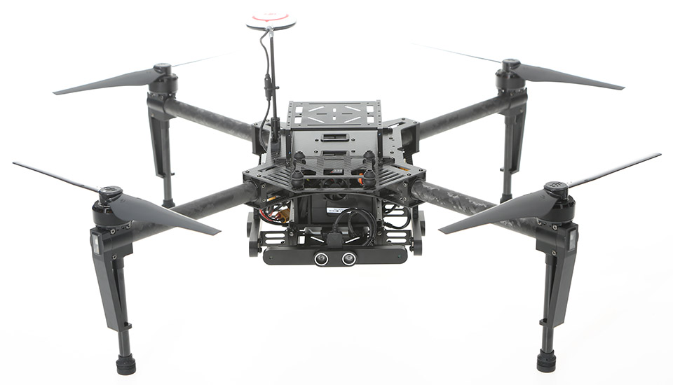
DJI Matrice 100 with the "Guidance" Sense and Avoid System

DJI Matrice 100
DJI continues to position itself at the forefront of high-end commercially developed UAVs, and when it comes to sense and avoid, they are clearly ahead of the pack.  In June of this year, DJI rolled out their Matrice 100 drone that comes equipped with a sense and avoid system (Prindle, 2015).  
The sense and avoid system, called “Guidance” by DJI, uses a combination of visual and ultrasonic sensors that are mounted fore, aft, left, right, and below the aircraft.  This provides 360 degrees of sensing at the horizon, as well as directly below the aircraft.  The data from these sensors is fused using DJI’s vision algorithms to perform the sense and avoid function.  This system also helps the aircraft to hover without GPS at altitudes of up to 65 feet (Guidance, n.d.).  I did note the omission of a sixth sensor mounted on top of the system that would provide coverage above the aircraft to keep it from running into the ceiling or other obstructions such as tree limbs, etc.  In all of the various discussions about this system, I couldn’t find a mention of this as being a concern.    
The Guidance System with Five Sensors and Processor
For the theory of operation on this system, as stated above, the system fuses visual (electro-optical or EO) and ultrasonic (sonar) sensors in order to provide the sense and avoid capability.  These sensors can be seen in the image to the below:
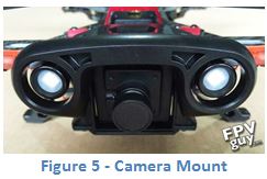
Single EO and Ultrasonic Sensor
The two EO cameras closer to the center, and the sonar sensors mounted farther out.  The EO sensors in this system provide a stereo matching in order to provide depth through the parallax effect of objects when viewed from the two cameras, as well as the ability to track motion (Sun, 2013).  The ultrasonic sensors are used to measure the actual distance from the object(s) that are being seen by the cameras (Wu, 2014).  The vision algorithm fuses the two modalities by continuously tracking visual information and updating the overall world model of the system (Tabkhi, 2014).       
Currently, the Matrice 100 is the only DJI airframe that has this capability.  Unlike other DJI aircraft such as the Phantom 3 or Inspire, the Matrice 100 is “developer-friendly” and was built specifically to support experimental research and development (Popper, 2015).  The Matrice 100 is available for around $3,300 from multiple sources online. 
Below is a list of technical specification on the system from DJI’s website (Guidance, n.d.):
Physical
Parameters
Dimensions
Guidance Core: 78.5 mm x 53.5 mm x 14 mm
Guidance Sensor: 170 mm x 20 mm x 16.2 mm
VBUS Cable: 200mm
Weight
Guidance Core: 64 g
Guidance Sensor (single): 43 g
VBUS Cable (single):11.6g
Performance
Parameters
Velocity Detection Range
0~16 m/s (From the ground 2 m) (The measurement shall prevail)
Velocity Detection Accuracy
0.04 m/s (From the ground 2 m)
Positioning
Accuracy
0.05 m (From the ground 2 m)
Effective Sensor
Range
0.20 m ~ 20 m
External
Requirements
Good lighting
Texture-rich surface with clear patterns
Hardware
Parameters
Power
Consumption
Max. 12 W (with all five Guidance Sensors)
Input Voltage
11.1 V~25 V
Operating
Temperature
-10°C ~ 40°C
System Interfaces
VBUS 5
CAN 1
USB OTG 2.0 1
UART 1
UART Level
3.3V

References:
Guidance. (n.d.). Retrieved December 5, 2015, from https://developer.dji.com/guidance/
Popper, B. (2015, June 8). DJI just released the first consumer drone that can see and avoid obstacles. Retrieved December 5, 2015, from http://www.theverge.com/2015/6/8/8745415/dji-guidance-system-matrice-100-sense-avoid
Prindle, D. (2015, June 9). DJI’s new obstacle avoidance tech aims to make drones crash proof. Retrieved December 4, 2015, from http://www.digitaltrends.com/cool-tech/dji-obstacle-avoidance-matrice-100-guidance/
 Sun, H., Zou, H., Zhou, S., Wang, C., & El-Sheimy, N. (2013). Surrounding Moving Obstacle Detection for Autonomous Driving Using Stereo Vision. Int J Adv Robotic Sy International Journal of Advanced Robotic Systems, 1-1.
Tabkhi, H., Sabbagh, M., & Schirner, G. (2014). Power-efficient real-time solution for adaptive vision algorithms. IET Computers & Digital Techniques, 16-26.
Wu, S. (2014). An optimized ultrasonic sensors system. Sensors & Transducers, 182(11), 33-41. Retrieved from http://search.proquest.com.ezproxy.libproxy.db.erau.edu/docview/1635079504?accountid=27203

Tuesday, December 1, 2015

Control Station Analysis - QGroundControl

The development of QGroundControl (QGC) rose out of the PIXHAWK Project around 2009/2010.  This open source application was initially designed around “aerial robotics using computer vision.” (PIXHAWK, n.d.)  Since this time, it has expanded out to allow operators and developers to be able to visualize and control air, land, and water autonomous unmanned systems, “during development and operation, both indoors and outdoors.” 
Although the system was initially designed around the PIXHAWK autopilot, the application has matured to include: PX4 Autopilot, ArduPilotMega, SLUGS Autopilot, FLEXIPILOT, UAVDevBoard/Gentlenav/MatrixPilot, SmartAP AutoPilot, Parrot AR.Drone 2.0, AutoQuad 6 Autopilot, as well as others.  Although the majority of the systems that seem to be targeted with this application are designed for aircraft autopilots, the developers have created a bridge that allows MAVLink to communicate with the open source Robot Operating System (ROS).  This messaging bridge enables the use of both unmanned ground and sea vehicles to be controlled using QGC.  MAVLink is the “Micro Air Vehicle Communication Protocol” that was also developed as part of the PIXHAWK Project in 2009.  MAVLink was designed to support an open standard to facilitate adoption by developers of other systems in order to support interoperability between the systems.  This protocol is being used on numerous autopilots, software packages, and other projects (MAVLink, n.d.). 
Some of the key features of this application (beyond being open source and supporting multiple autopilots!) include the visualization using 2D and 3D maps.  The system supports setting way-points directly in the Google Earth plugin (Whitehead, 2014): 
For sensor and telemetry data visualization, the system can plot this data in real time, as well as provide a heads up display for video from the vehicle’s sensor:
  
  
As part of this project, I downloaded and installed a copy of the application.  Overall, it was fairly quick to load and worked first time.  With only a couple issues, the application worked fairly smoothly; which is sometimes not the norm for open source applications.  One limitation of the system is that you only have a basic capability of route planning and playback if you don’t have an autopilot that you can connect into the application.  

Overall, I feel that this application has a lot of strengths and flexibility when it comes to controlling disparate systems (air, land, and sea) simultaneously.  In closing out this post, here's a quick video showing the application in use QGroundControl Demo:


References:    
MAVLink Micro Air Vehicle Communication Protocol. (n.d.). Retrieved from http://qgroundcontrol.org/mavlink/start
PIXHAWK. (n.d.). Retrieved November 29, 2015, from https://pixhawk.ethz.ch/
Whitehead, T. (2014, September 24). My Google Map Blog. Retrieved December 1, 2015, from http://mygmap.net/?tag=qgroundcontrol


Saturday, November 7, 2015

UAS Sensor Placement

Sensor placement is a critical design decision that is based on the objective that an unmanned system will be tasked to perform. For this assignment, I had to choose two commercial UASs that are currently available for purchase. One will be utilized to provide aerial photography services to include full motion video and still pictures below 400 feet Above Ground Level (AGL). The second UAS will be used as a First Person View (FPV) to compete on a racing circuit. 
  
For anyone that is looking for a UAV to provide aerial photography services like those described in the directions above, the Cadillac aircraft for this has got to be the DJI Inspire 1.  
First and foremost on this aircraft is the top of the line camera that can run at up to 30 frames per second (FPS) in 4k mode, or up to 60 FPS in 1080p HD.  This camera can also shoot 12 Megapixel still images too.  The camera mounts to the aircraft on a 3-axis 360 degree rotating gimbal.  
The developers of the Inspire wanted to maximize the ability of the gimbal, and so they designed the aircraft to drop the body (and therefore the belly mounted gimbal and camera) after takeoff (Figure 2).  This raised the quad’s landing gear well above the field of view of the camera to truly provide unobstructed views.  
To assist the quad in maneuvering, the aircraft has a combined sonar and visual sensor installed on the bottom to provide motion cues for the aircraft to aid in stabilizing the aircraft (See Figure 3).  One limit on the system is that at this time, the standard camera doesn’t offer a zoom.  Additionally, the aircraft also only has a flight time of 18 minutes, thus limiting any extended videos (Inspire 1, n.d.). 


Next, there are plenty of options for first person view (FPV) quadcopters for racing.  I picked the Walker Runner 250 Advance, which is a higher end copter with a decent amount of durability and a modular design that lends itself to quick repairs due to the inevitable crashes that will occur.  This quad comes with a 1080p/60 FPS camera, providing some of the clearest video possible (Drone, n.d).  
The camera is located directly below the “bumper” on the front of the aircraft. This provides the maximum view to the operator (110 degrees field of view), while still providing a level of protection.  
An optional camera (like a GoPro) can also be installed on the top of the platform.  
One of the key features of this model over previous Runner 250s is the GPS system, providing “return to home” and “altitude hold” functions for increased stability (Dronewallah, 2015).


References:
- Drone, Quadcopter, Multi rotor, Quadricopter, Multirotor, Drone. (n.d.). Retrieved November 7, 2015, from http://quadsforfun.wix.com/quadsforfun#!walkera-runner-250--runner-250-advance/c1ypr
- Dronewallah. (2015, August 27). Walkera Runner 250 Advance gets a GPS update! - rcDroneArena. Retrieved November 7, 2015, from http://www.rcdronearena.com/2015/08/28/walkera-runner-250-advance-gps-cheap/
- Inspire 1 - Everything you need for aerial filmmaking | DJI. (n.d.). Retrieved November 7, 2015, from http://www.dji.com/product/inspire-1